History and overview of Chipperfield today
Chipperfield is a small, active village situated on a crossroads approximately 5 miles south-west of Hemel Hempstead and the same distance north-west of Watford. It is just less than 2 miles across, east to west and north to south. It nestles on the edge of the chalky Chilterns sitting around 130 - 160 metres above sea level. The chalk is overlain with pebbly clay and sand to the south and east and clay with flints to the north and west. There are two dry valleys where the chalk is exposed at Dunny Lane and Whippendell Bottom. The roads are bordered by an attractive mix of gardens, fields, hedges and woodland rather than solid walls. There is an extensive network of delightful footpaths, pavements and permissive bridleways, most of which are well maintained. The white painted signposts and wooden public benches are in harmony with the character of the village.
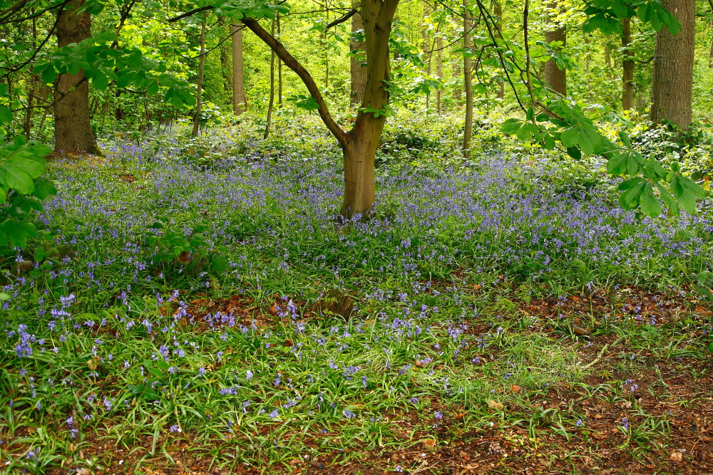
Chipperfield Common was gifted by the Blackwell family in 1936 to the local authority to be maintained in consultation with the people of Chipperfield. The Common extends to over 100 acres and is well used by local residents and visitors from the surrounding area. Most of the common woodland is secondary woodland estimated as varying in age between 80 and 176 years old, which has regenerated as the grazing of livestock fell out of practice. There are eight large mature sweet chestnut trees which are regarded as veteran trees, of great historical and landscape importance estimated to date back to between 1600 and 1620. The Common is the best known and valued feature in the village. There are also two known Bronze Age burial mounds on the common. The royal hunting grounds historically extended from the Langleys to Chipperfield common and some of the open ground in the centre of the village was originally connected to this. There is an ancient pond on the common which used to provide the monks with fish for Friday as it was outside the royal hunting ground and the monks were not allowed to hunt or fish within the royal park. The park was “disparked” by Queen Elizabeth I as the Palace and Friary in Kings Langley had fallen into ruin. “Chepervillewode was no longer the hunting ground of Kings and Queens and the Friars no longer came for fish”. Nowadays the whole of the parish has been included within the Metropolitan Green Belt. The centre of the village is contained within a conservation area designated to maintain the historical heritage of the village.
There are 16 designated footpaths across the common and farmlands giving a great opportunity for all to appreciate Chipperfield’s rural landscape. Despite its proximity to Hemel Hempstead and Watford, the village has maintained its rural character and surrounds with a mixture of open farmland, wooded areas and copses. The Bulstrode farmland is notable for its lack of hedges, since an area enclosed by 29 hedges has been consolidated into a single field. The farmland east of the Manor House and descending into the dry Whippendale valley is characterised by medium-sized hedged fields. It is considered attractive and was designated a Landscape Conservation Area under the Dacorum Borough Local Plan adopted in 1995. Fields come right into the village and provide an agricultural setting for adjoining housing. Chipperfield is a lively community of 1753(2011 Census) people living in over 800 households. It has a post office and general store, a grocer and provision store, newsagent, restaurant, deli, cafes, a garden centre and three pubs, a restaurant and a busy car dealership. Socially the village has three active churches; a village hall; a social club and youth club, each with their own premises. There are well-supported sports clubs for cricket, football, tennis, and many other activities take place at various locations throughout the week. The village primary school is at capacity, with over 200 children on the roll.
The village lacks a doctor’s surgery which means that villagers need to travel the two miles to facilities in Kings Langley, Bovingdon or Sarratt. Similarly, attendance at the dentist or at a day centre involves transport out of the village.
There are few employment opportunities in the village itself. There are now just three local farms, two involved in mixed farming and one solely arable. There are shops, a main dealer garage and garden centre, there are some employment opportunities in the local hospitality trade. However, many people commute to London or the local large towns. The village recently lost a car dealership and garden centre to housing development reducing the village employment opportunities further.
There are local bus routes providing daily service to Watford and Hemel Hempstead: the services are limited and, despite public subsidies, not well supported. Train and tube services are within a few miles at Hemel Hempstead, Kings Langley, Watford, Rickmansworth and Chorley Wood.
Due to its situation and the current road infrastructure, there is a considerable volume of through road traffic, the principal destinations being the M25 (junctions 18 and 20), Watford, Rickmansworth, Bovingdon and Chesham. The village is an attractive recreation area for visitors from neighbouring towns and villages and this adds to the central congestion and pressure on vehicle parking facilities, particularly at week-ends.
Chipperfield retains its rural or village feel whilst being close to all major amenities and employment opportunities. It provides a relatively quiet place to live and bring up a family or a very pretty place to visit and walk the dogs. The lack of effective public transport limits the options of those not lucky enough to own a vehicle and in these days of ecological sensitivity appears to be a missed opportunity.